Satellite imagery confirms what residents have been saying: a steady decline in biodiversity; major accidents, including fires, at industrial facilities; and a complete lack of wastewater management systems. In contrast, there are bales of gypsum and cement ready to be exported to Israel, some of which bear European logos. The companies that produce cement in Nitzanei Shalom are also involved in other businesses, including the export of weapons and warships to various parts of Europe.
The Nitzanei Shalom industrial zone is located on the western edge of Tulkarm, between the city and the separation wall. Established in the mid-1980s, it hosts Israeli factories operating on occupied Palestinian land. Over the past few decades, farmers, residents and workers have expressed concerns about the environmental and health impacts associated with the site.
Satellite imagery, planning documents, academic studies and fieldwork testimonies all point to the long-term transformation of the surrounding landscape. The images show how the industrial area has expanded into agricultural land, and researchers have documented soil, water and air contamination, including the presence of heavy metals and persistent industrial pollutants. Farmers describe a decline in agricultural productivity and an increase in restrictions on their access to land.
Satellite analysis also suggests an apparent lack of visible wastewater treatment infrastructure for industrial discharge, runoff and washing water. This fact is also proven by the testimony of farmer Fayez Taneeb, who had to pave a canal on his land to divert wastewater from the factories.
The investigation traces the commercial relationships between companies operating in the industrial zone and those in international markets. This includes establishing links to European business networks and supply chains.
Although the European Union considers Israeli settlements in the Occupied Palestinian Territories (OPT) to be illegal under international law, commercial links between Nitzanei Shalom and European markets persist, highlighting the discrepancy between the EU's legal stance and the execution of its trade policies.
Aside from Alessandro and Filippo, the team included two Palestinian journalists, whose identities must remain secret for security reasons.
Key findings
- Analysis of satellite imagery reveals the long-term expansion of the industrial zone into agricultural land, as well as a decline in the green spaces in the area. There appears to be an absence of visible wastewater treatment infrastructure.
- Testimonies from residents, farmers and locals who have faced health and environmental harm from the industrial zone, such as land grabbing, crop damage, major fires and health issues.
- Academic reports conducted upon the team's request from academics and researchers in Palestine and Italy to assess the previous studies conducted in this matter which explained that the environmental situation in Tulkarm may worsen if current pollution sources continue without effective mitigation, with the emphasis of the need for preventive measures, including continuous monitoring of water and soil, increased community awareness, safer agricultural practices, and the treatment of contaminated water before use.
- Documentation of Israeli companies operating inside the industrial zone, including Israel Shipyards, Cement IS, Tambour, Orbond and other firms with limited public visibility in Europe.
- Mapping of commercial, industrial and corporate links connecting companies in Nitzanei Shalom to European business networks and supply chains.
- Several Israeli companies operating in Nitzanei Shalom maintain commercial and industrial relationships with European businesses, including companies based in Greece, Germany and Italy.
- Gap between the European Union’s legal position on Israeli settlements and the continued existence of commercial relationships involving companies operating in occupied Palestinian territory.
- Some companies operating in Nitzanei Shalom have links to Israel’s defence and military-industrial sector.
Methodology
The project was conducted using an interdisciplinary methodology that combined field reporting, visual work, academic review and document analysis with remote sensing. Fieldwork enabled direct observations to be made and contacts to be established with academic institutions and relevant governmental bodies in both Europe and Palestine. Reporting also involved engaging with civil society actors, whose testimonies helped to reconstruct local environmental and social conditions.
Satellite imagery analysis, supported by Planet.com and Placemarks, was used to evaluate the long-term spatial and environmental changes within and around the industrial zone. This was supplemented by an internal review of corporate structures and commercial links within Israel, as well as between Israeli companies and European markets.
In order to cross-reference sources and corporate data across jurisdictions, the research was conducted in multiple languages, including Hebrew, Italian, English, Arabic, Greek and Turkish. We also analysed official documents and databases used in recent major international investigations, and we had access to the experimental database of the Cross³ project.
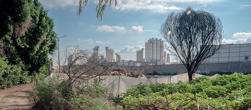
Image © Alessandro Stefanelli: A road running alongside the Nitzanei Shalom industrial complex leading toward Palestinian agricultural lands. Tulkarem, West Bank, Palestine. Every morning at 6 a.m., farmers attempt to access their fields to work them, trying to avoid being seen by Israeli soldiers who restrict access and reportedly open fire when individuals are spotted.